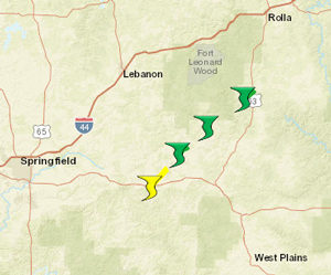
 The National Weather Service Forecast Office in Springfield, Missouri confirms that 3 tornadoes struck our County Warning Area during the early morning hours of Thursday, May 3, 2018.
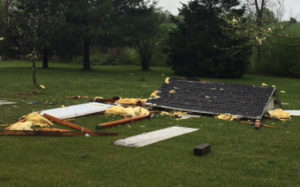
The first and the strongest tornado in this series, an EF-1 with peak winds near 95 miles per hour, hit Christian County at around 2:10 a.m. Surveyors say the tornado touched down around 2 1/2 miles north of Ozark with the damage path beginning near the intersection of North 3rd Street and Sunset Road where minor roof damage occurred (see photo to the left). The storm then moved northeast causing additional roof damage, snapping trees, and destroying outbuildings along its path before lifting near the end of Peartree drive. This tornado had a maximum width of 100 yards and spent around 3 minutes on the ground travleing a total of 1.2 miles.
The second twister clipped the southeastern corner of Greene County at about 2:17 a.m. This EF-0 tornado had peak winds of around 80 miles per hour and spent only a minute on the ground leaving a path just 50 yards wide and about one-quarter of a mile long. A barn was destroyed and trees were uprooted near the intersection of East Farm Road 186 and Farm Road 241 just west of Rogersville.
The third tornado hit Douglas County around 1.5 miles northeast of Squires at around 2:45 a.m. This EF-1 twister had peak winds around 90 miles per hour. It spent about two minutes on the ground traveling a total of three-quarters of a mile with a maximum width of around 75 yards. This tornado destroyed one outbuilding and blew the roof off of a new cattle feeder. Several trees were reportedly uprooted and snapped.
Forecasters say the severe weather came in two waves. The first one hit late in the evening of May 2nd into the early morning hours of May 3rd. This line affected mainly portions of west-central into central Missouri dropping hail up to 1 inch in diameter in St. Clair County. The second line of storms started moving into extreme southeast Kansas and southwest Missouri just before midnight with several damaging wind reports. It was this second line of storms that sparked these brief spin-up tornadoes. Fortunately, no injuries or fatalities have been reported.
 The benefit concert on April 26th in Houston, Missouri featuring Country music band Farewell Angelina was a huge success with a near-sellout crowd in attendance. The four-member all-female band performed several songs including covers of classic hits made famous by The Eagles and The Animals as well as a cover of an appropriately-titled song: “Radioactive” made famous by Imagine Dragons. Make no mistake, though, the sounds and harmonies were pure Country from start to finish. Cheers and applause from the enthusiastic and energetic crowd were unbridled throughout the evening.
 A strong storm system tracked through the Springfield, Missouri County Warning Area during the late afternoon and evening hours of Friday, April 13, 2018, dropping hail as large as tennis balls, damaging straight-line winds, and four tornadoes along its path.
 Country Music band
  The National Weather Service is encouraging you and your family to know where your severe weather safe place is at home, at work, at school, and even at places in between. From now until April 4th, you are encouraged to take a photo of yourself and your family (aka: a selfie) while inside your severe weather safe place. Then post this photo on social media with the hashtag: #safeplaceselfie
 Daylight Savings Time begins this weekend here in Southwest Missouri and throughout most of the United States. This Sunday, March 11, 2017, at 2:00 a.m. local time, we spring forward to Central Daylight Time as we turn our clocks ahead one hour. Safety officials also suggest that this is a great time to test and/or replace the batteries in your smoke detectors and carbon monoxide detectors.
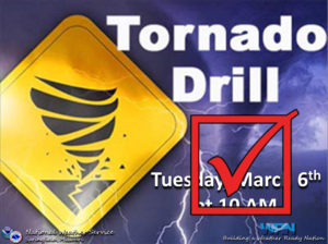 Thank you to all stations who participated in the amateur radio portion of this morning’s Statewide Tornado Drill throughout the Springfield, Missouri County Warning Area. We had a total of 81 stations participating!!!