
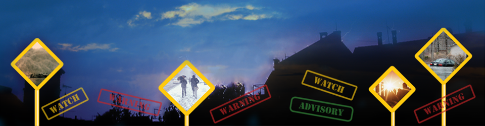
The National Weather Service is striving to support a “Weather-Ready Nation” by ensuring you are aware of and prepared for the variety of weather and water-based hazards we experience across the country every day. One factor in supporting this awareness and preparedness is to make sure their messaging is as clear and focused as possible.
For decades, the NWS has used the Watch, Warning, and Advisory (WWA) system to alert users of forecasted hazards. In many ways, the WWA system has been highly effective in protecting life and property. With that said, as they have collected feedback during the course of this project, they have learned that some users find the WWA terms confusing. Also, users are sometimes confused about how to interpret and distinguish among the large number of individual WWA “products” (e.g., Wind Advisory, Flood Watch, Winter Storm Warning).
Based on this initial feedback, and with support from social and behavioral scientists, NWS is exploring alternatives for more effectively communicating our hazard messages. The NWS says it is not making any changes to the operational system at this time but that they are carefully considering a number of options, as follows:
- Keep the current WWA system as is;
- Make small to moderate changes; or
- Make a transformational change to the WWA system.
Given that the WWA system has been in place for a very long time, the National Weather Service says it will be important to weigh any and all new ideas carefully, and to consider making initial small improvements while they continue to investigate the possibility of larger change. To support both efforts, the National Weather Service is collecting public comments on these options as they move forward.
Visit their new “Hazard Simplification” webpage at http://www.weather.gov/hazardsimplification/ and let your voice be heard. You can read more information about this project and participate in an online survey.
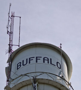 Following several weeks of work and testing, we’re excited to announce that the Buffalo, Missouri repeater at 147.180 MHz. is now permanently linked into the Southwest Missouri Regional Skywarn linked repeater system. It took quite a bit of time to gather the resources to get this repeater to where it can be regularly linked. System trustee Mike, N0NQW, says the Buffalo Repeater has been outfitted with a brand new Yaesu Fusion DR-1X Repeater, a brand new commercial Vertex VX 2200 link radio, and a new CAT repeater controller. Unfortunately a preexisting issue with the antenna and feed line atop the tower continues to produce occasional bursts of static over weaker signals transmitting into this repeater. These static bursts sound a lot like the noise that nearby lightning makes on a radio receiver. At this time it seems unlikely that we will have the financial resources available to try to correct this problem prior to the scheduled razing of the water tower upon which the repeater’s antenna is mounted. So, in the meantime, you may have to use high power to reliably access this repeater. Once we are able to raise the funding needed to move the Buffalo Repeater to its new location following the water tower’s demolition, this problem will be resolved.
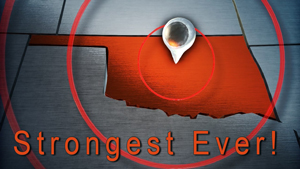 Saturday’s earthquake, which was felt by spotters throughout the Springfield, Missouri County Warning Area, is now on record as the strongest earthquake in Oklahoma history! The United States Geological Survey says the official magnitude of the September 3, 2016 Pawnee, Oklahoma earthquake is now 5.8 (up from 5.6).
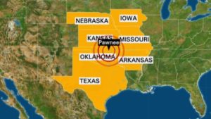 The morning of Saturday, September 3, 2016, is certainly one for the books for a couple of reasons. Of course the big story was the California-sized earthquake that struck the Pawnee, Oklahoma area and shook the western portions of our County Warning Area out of bed shortly after 7 o’clock. At 5.6, this ties the all-time record quake magnitude for Oklahoma set back in 2011*. Immediately following the main shock, several hams began exchanging information across the Southwest Missouri Regional Skywarn linked repeaters, and, after just a couple of minutes, it became clear that the shaking was worse the further westward you went. While this wasn’t good news for the weary residents of northern Oklahoma, for those of us pondering the potential time bomb that may lie underneath the boot heel of Missouri, it served as a small relief.
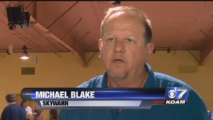 Amateur Radio and Skywarn scored big with some really good television media coverage this past weekend during and after the Joplin Hamfest. On Saturday, KOAM-TV Channel 7 visited the Hamfest. Reporter Chloe Leshner spoke to Southwest Missouri Regional Skywarn’s N0NWS Repeater Trustee Michael Blake, N0NQW. During the interview, Mike was able to remind folks that during the devastating 2011 tornado in Joplin, trained spotters were on the ground relaying information back to the National Weather Service using our linked repeater system and were therefore able to help meteorologists to disseminate advanced warnings to the citizens of Joplin.
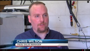 Following the Hamfest, KODE-TV Channel 12 reporter Cortney Brown did an even longer story on how Skywarn and the National Weather Service are benefiting from the new analog/digital hybrid system known as Yaesu System Fusion. Once again N0NWS Repeater Trustee Michael, N0NQW was interviewed along with fellow system control operator and Yaesu System Fusion representative Chris Wilson, N0CSW and storm chaser Jordan Hamilton, KC0SHN. An interesting point made during this interview is how Yaesu System Fusion allows the National Weather Service to get quicker and more accurate reports of what’s happening on the ground thanks to the digital system’s GPS. Think of it this way: If seconds save lives (and they do in these situations), then how much time can be saved during an outbreak if a spotter or chaser doesn’t even have to stop and think about his or her location and then report it because the National Weather Service already knows thanks to the GPS reporting? And, if time is being saved, then so are lives!
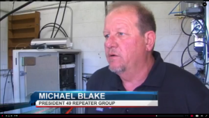 This is big, and, on behalf of the amateur radio community, we at Southwest Missouri Regional Skywarn would like to thank Channel 7 and Channel 12 in Joplin for helping remind the public how amateur radio is here and ready to serve at a moment’s notice. And, as new technology becomes available and evolves, we work hard to implement all of new benefits available from it.
 A brand new net targeted at younger amateur radio operators debuts this Sunday, September 4th on the Southwest Missouri Regional Skywarn linked repeaters. The purpose of this net is to provide a forum to encourage young amateur radio operators and their families to key up and get out on the air and to create an educational awareness among these operators about Skywarn and basic weather facts.
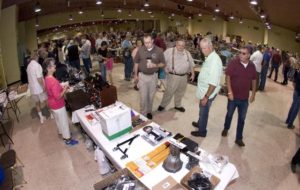 The Joplin Hamfest is coming up this Saturday, August 27th from 8 a.m. until 2 p.m. at the Hammons Convention Center in Joplin. It will be one day only this year, and it will feature an electrical test bench/area to check your used equipment. An ARRL VE-Testing session will take place on Saturday 8 a.m. inside a conference room at nearby La Quinta Inn – the host hotel for this year’s hamfest.
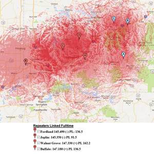 Southwest Missouri Regional Skywarn’s Interactive Repeater Coverage Map is online. Give it a try. Just click on the “
 Follow Southwest Missouri Regional Skywarn on Twitter