N0NWS.com: One Year Later

July 4thAs we prepare to celebrate a very special and important anniversary this coming Tuesday, there’s a first anniversary that takes place today: Saturday, July 1, 2017. One year ago today this website was launched! Thanks to the content contributions of many hams in the community, visitor traffic to n0nws.com has quadrupled over the past year. Please keep it coming! Let us know how this website can continue to grow and improve, and we will do our best to make it happen.

For those of you who regularly check into our Skywarn Training Nets on Tuesday evenings as well as helping to encourage youth and family members during the Sunday evening Youth/Family Net: Thank you!

Our linked repeater system has grown significantly in the past year as well. We now have double the amount of repeaters in service. Because of our owned-and-operated and our affiliated repeaters, the Southwest Missouri Regional Skywarn Repeater Network now covers more territory than any other linked repeater system in Missouri with coverage spanning into three neighboring states. Our coverage now extends south past the Arkansas border and northward to the Missouri River! With the upcoming linking of the 146.745 repeater in Macomb, our eastward coverage increase along the Highway 60 corridor will be considerable. Heading west, thanks to the Joplin repeater at 145.350 Mhz, our coverage extends well into northeast Oklahoma and southeast Kansas.

Operating and maintaining these repeaters costs a fortune. We owe a huge thank you to everyone who donated during the past year including:

KE0HRS – Laurie in Springfield, MO
N0UAM – Jim in Springfield, MO
N0OCP – Joye in Bolivar, MO
KD0ISH – Richard in Stockton, MO
NA0OO – Marvin in Joplin, MO
KE0FGZ – Brad in Goodson, MO
KC5NWD – Kent in Grove, OK
N0KDN – Mark in Willard, MO
KD0ZRF – Janet in Springfield, MO
W0JOE – Joe in Rogersville, MO

Because of your generosity, the Buffalo Repeater at 147.180 MHz. will benefit significantly. Thank you!

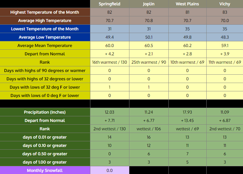
And, of course, most importantly, to our Skywarn spotters along with our faithful and hard-working net control operator: Jim, N0UAM, and the guys and gals at the National Weather Service Forecast Office in Springfied, Missouri – thank you for keeping the information flowing during severe weather. The spring severe weather season is over for 2017, and because of you, we have been able to continue our mission of protecting lives and property throughout the Springfield, Missouri County Warning Area: Thank you!

To Mike, N0NQW, all of the affiliated repeater trustees, and the other technical geeks who keep the “magic smoke” from leaking: Thank You!

Happy Independence Day! Have a safe and blessed summer!

Public Field Day Events in SW Missouri

2017 ARRL FIeld Day

Here’s a list of a few of the Public Field Day Events in SW Missouri. Field Day starts at 1 p.m. Central (1800 UTC) Saturday, June 24, 2017 and continues for 24 hours.

Christian County (Ozark, Missouri):  Click Here for a Map
Christian County A.R.E.S. will be operating at the location of the Old Riverside Inn along Riverside Road just north of Finley River Park in Ozark, MO.

Douglas County (Ava, Missouri): Click Here for a Map
The DCAR Radio Club will be operating at 309 N. Jefferson Street in Ava, MO which is the Lions Club building. You can email Teresa KC0OKP at kc0okp@yahoo.com for more information.

Texas County (Houston, Missouri): Click Here for a Map
The Ozark Mountain Amateur Radio Club will be operating in front of Pizza Express in Houston, Missouri. Free Dinner will be served around 5 – 6 p.m. on Saturday!
More information: Via this Newspaper Article

Newton County (Joplin/Diamond, Missouri): Click Here for a Map
The Joplin Amateur Radio Club will be operating from Camp Childress Boy Scout Camp at 12255 State Hwy V, near Diamond, MO.
More information: http://joplin-arc.org/field-day/

Phelps County (Rolla, Missouri): Click Here for a Map
The Rolla Regional Amateur Radio Society will be operating from the Rolla Lions Club Den and Park in Rolla, Missouri.
More information: http://www.rollanet.org/~rrars/fieldday.html

Camden County (Camdenton, Missouri): Click Here for a Map
Lake of the Ozarks Amateur Radio Club will be operating at the Missouri Conservation area on Thunder Mountain Road in Camdenton.
More information: http://www.loarc.com/?page_id=663

2017 A.R.R.L. Field Day: June 24th & 25th

2017 ARRL FIeld DayThe annual A.R.R.L. Amateur Radio Field Day is next weekend! While it’s formatted like many other American Radio Relay League contests, Field Day has much more purpose than just racking up contacts. The A.R.R.L. says that Field Day is ham radio’s open house with one of its main objectives being learning to operate in abnormal situations in less than optimal conditions. In other words, it encourages us to get out and show off the hobby to others while practicing and preparing for emergencies. The A.R.R.L. adds that Field Day, “…combines public service, emergency preparedness, community outreach, and technical skills all in a single event.”

Field Day is always held on the fourth weekend of June. The on-air portion of it starts this year on Saturday, June 24, 2017 at 1 p.m. Central and lasts for 24 hours.

According to the A.R.R.L.’s online Field Day Locator, the Douglas County Amateur Radio Club will be hosting a public Field Day event in Ava, Missouri. The listed address is 309 N. Jefferson Street in Ava which is the Lions Club building. You can email Teresa KC0OKP at kc0okp@yahoo.com for more information.

Whether you go to a public Field Day event or stay home and make a few contacts, let the last weekend of this month be a time for you to review your amateur radio setup and see how you can better prepare yourself to stay on the air following a disaster.

Visit the A.R.R.L. Field Day page for more details at: www.arrl.org/field-day

F.E.M.A. Assistance for Storm Victims

2017 FEMA Assistance for Missouri Storm Victims
As we get ready to welcome summer with arms wide open on Tuesday, June 20th at 11:24 p.m. Central, the cleanup from our recent deadly springtime severe weather throughout the Springfield, Missouri County Warning Area continues. A total of 27 counties are eligible for financial assistance from The Federal Emergency Management Agency. Officials are urging residents of these 27 Missouri counties designated in the federal major disaster declaration to register with the agency without delay.

Registration is easy:

Eligible homeowners and renters may be able to receive money for disaster expenses not covered by insurance to help pay for basic home repairs, temporary rental assistance and other needs such as replacing personal property. FEMA Individual Assistance is grant money that does not have to be repaid.

FEMA Federal Coordinating Officer Michael Parker says not to wait for a Disaster Recovery Center to open in your area. He says folks should register now and start the process as soon as possible.

Filing an insurance claim does not start the FEMA registration process. Neither does registering with the American Red Cross or other agencies. To be considered for FEMA grant assistance, applicants must register directly with FEMA. Even if they have insurance coverage, FEMA might be able to assist with disaster expenses that aren’t covered by insurance.

The 27 counties affected by the April 28th through May 11th flooding that have been designated for FEMA’s Individual Assistance program are: Bollinger, Butler, Carter, Douglas, Dunklin, Franklin, Gasconade, Howell, Jasper, Jefferson, Madison, Maries, McDonald, Newton, Oregon, Osage, Ozark, Pemiscot, Phelps, Pulaski, Reynolds, Ripley, Shannon, St. Louis, Stone, Taney, and Texas.

Missourians who have critical unmet needs are encouraged to call United Way 2-1-1, which can provide access to other assistance provided by voluntary agencies, faith-based organizations and state agencies. Those who have already called 2-1-1 for help with disaster recovery needs still need to register separately with FEMA.

After registering with FEMA, all businesses and most residents will be referred to the U.S. Small Business Administration (SBA). SBA provides federal low-interest disaster loans to businesses of all sizes, private nonprofit organizations, homeowners, and renters impacted by this disaster. SBA disaster loans are to help pay for disaster repair or replacement costs not fully covered by insurance or other sources. In addition, for small businesses and most nonprofit organizations SBA disaster loans can help meet disaster-caused working capital needs. There is no cost or obligation to apply to SBA.

Homeowners and renters should apply to SBA, even if they are not sure if they will need or want a loan. If SBA cannot approve their application, in most cases SBA refers them to FEMA’s Other Needs Assistance (ONA) program for possible additional assistance

SBA representatives are at all of the Disaster Recovery Centers to help each applicant apply. Applicants may also apply to online at https://disasterloan.sba.gov/ela, contact SBA for additional information at 800-659-2955 or email disastercustomerservice@sba.gov.

Earthquakes Rattle Parts of C.W.A. Again

June 2017 Harrison Arkansas EarthquakesIn a flashback to last September, another series of earthquakes were felt throughout parts of the Springfield, Missouri County Warning Area last weekend. While these quakes centered between Harrison, Arkansas and Bull Shoals Lake were significantly weaker than the magnitude 5.8 quake that hit Pawnee, Oklahoma on September 8, 2016, they were much closer and were felt by folks in Stone, Taney, and Ozark Counties.

The main quake hit at 7:40 a.m. on Sunday, June 11, 2017, and had a magnitude of 3.6. It was followed by 6 very weak aftershocks. Boone County, Arkansas Emergency Management Officials are reporting no injuries or major damage.

Details about the quakes including a map can be found by clicking here.

Missouri Summer Weather Safety Week

2017 Missouri Summer Weather Safety Week: Excessive Heat and Lightning
June 18th – June 24

2017 Missouri Summer Weather Safety Week

The National Weather Service, the Missouri Department of Health and Senior Services, and the State Emergency Management Agency are joining together to promote Missouri Summer Weather Safety Week 2017: Excessive Heat and Lightning. The following is important safety information that can save people’s lives. Please help spread the word about excessive heat and lightning safety so everyone can have a safe summer.

Before heading to the park, lake, scenic river, ball game or to any outdoor activity be ready for unexpected or even hazardous weather conditions. Get the latest forecast before heading out. Monitor NOAA Weather Radio, local media, or favorite weather app. Pay attention to changing weather conditions (changing skies, winds, or temperatures).
Listen for thunder. Monitor stream levels. Be aware of the effects of excessive heat.

During the past 10 years heat has killed nearly 20 times more people than lightning in Missouri!

The National Weather Service has a trove of information on their website on how you can can stay safe this summer. Visit this link for safety tips, videos, and more.

May 27th Deadly Severe Weather

May 27, 2017 Missouri Deadly Severe Weather
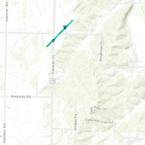
The National Weather Service in Springfield, Missouri confirms that five tornadoes touched down within our County Warning Area during the afternoon hours of Saturday, May 27, 2017 disrupting Skywarn coverage in the process. All five tornadoes were rated at EF-1 and had estimated winds of 90 miles per hour. They occurred within a one-hour span starting at 2:38 p.m. Central Time near Lake of the Ozarks with the final confirmed tornado hitting at 3:25 p.m. near Fort Leonard Wood. No injuries were reported with these tornadoes. Of direct interest to Skywarn: the tornadoes near Lake of the Ozarks knocked out power to our affiliate repeater in Laurie, Missouri on 146.955 MHz. This outage lasted for around 2 days and also disrupted service to three major cellular telephone companies as well as broadcast radio station KRMS AM & FM.

As the final tornado in this timeline was touching down at Fort Leonard Wood, things became interesting when the situation seemed to transition into a significant straight-line wind damage event that was around 50 miles long! Storm survey crews say this destructive swath of wind started in far southeastern Laclede County. It then continued across northern Texas County, southern Pulaski County, southern Phelps County, western Dent County, and ended in central Dent County. Reports say areas of large trees were uprooted or snapped off. Utility lines and poles were blown down or hit by falling trees aloMay 27, 2017 Missouri Straight Line Winds
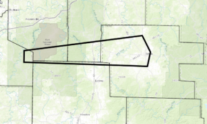
ng most of this event’s path. The hardest hit areas with more concentrated damage, including structural damage, were the communities of Edger Springs, Salem, and along portions of Highway 17. Both communities experienced minor to major damage to homes, businesses, and outbuildings. In one instance, the metal roof and main structure of a church gym in Salem was crushed downward which indicated a downburst wind up to nearly 100 m.p.h. Reports of vehicle, roof, and window damage were numerous across these communities. Some rural communities such as north of Evening Shade, Palace, Big Piney, and along Highway H sustained some structural damage with numerous trees falling on vehicles and roofs. Several outbuildings were severely damaged or destroyed. Some additional highways like Highway 63, Highway C, Highway DD, Highway 72, Highway 68, Highway 19, and Highway 32 were impacted by these intense straight line winds. Servey crews say that based on the damage from this event, wind speeds of 80 to 95 miles per hour were common along with several areas of downburst winds that possibly reached up to 100 m.p.h.

Forecasters with the National Weather Service Forecast Office in Springfield say this severe weather outbreak was the result of extreme amounts of instability in the atmosphere combined with strong wind shear which created a volatile atmosphere. The results were the multiple thunderstorm line segments which produced the spin-up tornadoes and the destructive straight-line winds. Additionally, supercell thunderstorms also developed and were responsible for the very large hail. There were numerous reports of hail between 1 and 2 inches in diameter throughout our County Warning Area with one report of injuries near Carthage, Missouri due to the hail shattering a vehicle’s windshield. Meanwhile, just north of our C.W.A. in Adrian, Missouri, there were reports of grapefruit-sized hail which caused significant damage!

May 27, 2017 Missouri Deadly Torrential Rain
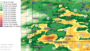
As the storms congealed into a west-to-east oriented line, torrential rainfall resulted in deadly flash flooding. Forecasters say the heaviest rainfall occurred in the Branson, Missouri area where 3 to 6 inches of rain fell in about a three hour stretch. This resulted in significant flash flooding of local creeks including Fall Creek, Cooper Creek, and Roark Creek. Multiple businesses and the Branson Campground were flooded as these creeks rose out of their banks. Several water rescues were conducted near these creeks as water rose quickly. Fall Creek reportedly rose as much as 14 feet in just 15 minutes! Sadly three people in Branson, Missouri died after their vehicle was swept away at a low water crossing along Fall Creek Road.

For details about this deadly severe weather outbreak including tornado track maps, please click here.


16 Tornadoes, 27 Hours, & A Little Irony

May19 &20, 2017 Missouri TornadoesIf you have ever lived in a part of the world where the weather is mundane day in and day out, it might be hard to imagine how quickly things can change here in Southwest Missouri. Take Southern California for example where the television weather folks are often out-of-work comedians and actors desperate for a gig. They can seemingly record a TV weather segment and replay it over and over for weeks at a time with total accuracy.

Not here. The year isn’t even half over, and there’s probably a lot of new ink in the record books for 2017. It’s not known at this time where the May 19th through May 20th severe weather event will rank compared to past happenings. However, it will certainly be one to remember – at least for a while – with a total of 16 tornadoes confirmed throughout the Springfield, Missouri County Warning Area in only 27 hours along with a bit of irony.

Fortunately the tornadoes which impacted the area were the spin-up type. As compared to the devastating twisters which drop down from supercell thunderstorms, these types of tornadoes are much weaker, smaller, and short-lived. According to the National Weather Service Forecast Office in Springfield, Missouri, this latest batch of tornadoes were the result of several waves pivoting around an upper level storm system as it moved eastward across the central Rocky Mountains. It was those waves, in conjunction with a stationary surface front extending from central Illinois across central Missouri and into south-central Kansas along with a very warm, moist, and unstable air mass that fired off the thunderstorms and the tornadoes.

The average estimated speed of these tornadoes was 87 miles per hour. Interestingly, the strongest and the weakest of these tornadoes happened within a few miles and a few minutes of each other near the Branson area in Taney County, Missouri. The strongest tornado, an EF-1 with estimated winds of 100 miles per hour, hit the Rockaway Beach area along Lake Taneycomo at about 1:30 a.m. on Friday, May 19th. It traveled nearly 9 miles toppling trees and knocking out power all the way to Taneyville. Meanwhile, the weakest tornado of the bunch hit just two minutes earlier in the heart of the Branson Strip. This tornado, a weak EF-0 with estimated winds of around 75 miles per hour, hit the Tanger Outlet Mall and a nearby hotel. Ironically, it was this tornado, the weakest of the cluster, which caused the only report of injuries of this entire event.

We thank Jim, N0UAM, along with all of our spotters for their help during this marathon severe weather event. For a complete list of the confirmed tornadoes from the May 19th through May 20th event along with track maps, please click here.

EF-0 Tornado Confirmed in Newton County

Newton Coounty Missouri Tornado May 11, 2017The National Weather Service in Springfield, Missouri is confirming that an EF-0 tornado touched down nothwest of Neosho in Newton County during the early morning severe weather event of Thursday, May 11, 2017. The 100-yard-wide tornado touched down near the intersection of Gateway Drive and Jute Road uprooting several trees and causing minor damage to several roofs and damaging or destroying several outbuildings. Surveyors say the tornado hit at 12:34 a.m. Central Time and only stayed on the ground for one mile. Peak winds are estimated at 85 miles per hour. No injuries or fatalities were reported.

Forecasters say this first wave of severe weather on May 11th was caused when a surface front, initially across northern Missouri, moved slowly southward as an upper level low over the southern Rockies made its way eastward into the Central Plains.  This surface front then stalled as it approached the Missouri-Arkansas border.  A very moist and unstable air mass south of the front set off several rounds of severe weather.  It was this first round early in the morning of May 11th which spawned the tornado.

Later rounds of severe weather during the mid morning and afternoon hours garnered several reports of strong winds and hail up to the size of golf balls throughout our County Warning Area southward into northern Arkansas.

So far there are no confirmed reports of a tornado resulting from a tornado-warned storm which set off warnings in Lawrence, Christian, and Greene Counties late Thursday afternoon. You can find more information on the May 11, 2017 severe weather event from the National Weather Service in Springfield, Missouri by clicking here.


April 2017 Warm, Record Rainfall

The National Weather Service Forecast Office in Springfield, Missouri says April 2017 was a month with above normal temperatures across the area and near record to record breaking rainfall throughout Southwest Missouri and extreme Southeast Kansas.

Here are some links to significant weather events through the month:

April 4th, Severe Storms and Tornadoes

April 26th Tornado

April 28th – 30th – Historic Flooding Event

Click the graphic below for more details…

April 2017 Missouri Ozarks Climate Summary