
 Storm survey crews from both the National Weather Service in Little Rock, Arkansas and the National Weather Service in Springfield, Missouri are confirming an EF-1 tornado which they say formed last week in Northwest Arkansas and skinned Barry and Stone Counties before dissipating. The tornado formed when a line of strong to severe thunderstorms moved from eastern Oklahoma into northwest Arkansas and southwest Missouri during the late night hours of Tuesday, April 25, 2017.
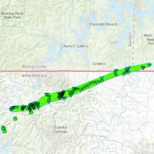
Shortly after 1 a.m. on Wednesday, April 26th, the line of storms developed a bowing segment as it was approaching the Arkansas/Missouri state line. An embedded circulation produced an EF-1 tornado that touched down in Carroll County, AR at 1:22 a.m. The tornado spent most of its time on the ground in Carroll County, AR before barely clipping the far southeastern corner of Barry County, MO at approximately 1:34 a.m where it was estimated to be about 1,000 yards wide. One minute later the tornado exited Barry County after leaving a path less than a mile long. It entered Stone County, MO where it maintained its estimated width of 1,000 yards while traveling for about 2 miles before dissipating at 1:38 a.m.
The total path length for the tornado in both Arkansas and Missouri was 16 miles. The majority of the EF-1 damage occurred in Arkansas where the tornado reached a maximum width of 1,500 yards.
The tornado produced a lot of tree damage, but no damage to structures, homes or other properties is being reported. There were no injuries or fatalities.
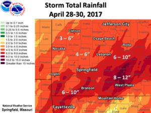 Historic flooding continues following a powerful storm system which brought torrential rainfall to the Missouri Ozarks and southeastern Kansas from Friday night, April 28 through Sunday, April 30. Widespread damage, fatalities, and historic flooding have resulted. According to reports from the National Weather Service Forecast Office in Springfield, Missouri, storm total rainfall amounts generally ranged from 4 to 8 inches with some areas of far southern and south central Missouri receiving from 10 to around 12 inches. Numerous roads, bridges and buildings were destroyed. Many roads were flooded through the event including state highways and Interstate 44. Several rivers continue reaching major and historic levels.
 We are excited to announce that Southwest Missouri Regional Skywarn now has full time coverage into the Lake of the Ozarks area! The KA0RFO repeater transmits on a frequency of 146.955 MHz. with a standard minus ( – ) offset and a PL tone of 192.8 Hertz from a tower 500 feet above Laurie, Missouri. This repeater serves the entire Lake of the Ozarks region with coverage as far north as Jefferson City, Missouri.
 equency of 145.33 MHz. with a standard minus (-) offset and a PL tone of 156.7 Hertz from atop Cox South Hospital in Springfield, Missouri.
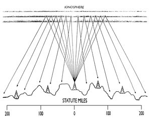 A recent test of the ability of several healthcare facilities throughout our County Warning Area to communicate via HF is being considered a huge success. Under the leadership of Polk County, Missouri A.R.E.S. Emergency Coordinator Joye, N0OCP, the purpose of this test was to break new ground in an effort to test whether direct communications from facility to facility is possible without using repeaters. Every three months, a net is held across the Southwest Missouri Regional Skywarn linked repeaters to make sure the emergency radios at these healthcare buildings work and can communicate. While reliance on a linked repeater system makes communications over several hundred square miles possible on VHF, the question that seemed to loom was: “What happens if the repeaters are off the air?” Despite mediocre conditions across the HF bands lately, the use of Near Vertical Incidence Skywave (or N.V.I.S.) on 80 meters proves to be a very reliable way to communicate regionally with relative ease.
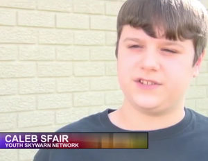 Southwest Missouri Regional Skywarn would like to thank reporter Jeremiah Cook and television stations KSN-TV 16 and KODE-TV 12 in Joplin, Missouri for covering our recently-launched Skywarn Youth Net on their evening newscasts on Sunday, April 10, 2017. Featured in the interview was 13-year-old Caleb, KE0FOE, who is one of three young hams who take turns running the Skywarn Youth Nets on Sunday evenings at 7:30 on most of our linked repeaters. The net debuted in early September 2016.
 A strong storm system barreled through Southwest Missouri on Tuesday evening producing severe thunderstorms and a few supercells with tornadoes, damaging winds, and hail. The National Weather Service in Springfield, Missouri says an EF-2 tornado hit the town of Goodman in McDonald County, Missouri causing significant damage to homes and businesses including Goodman Elementary School. The tornado touched down at about 6:48 p.m. It traveled 15 miles into southern Newton County to the southeast of Neosho with estimated peak winds of 120 m.p.h. and a maximum width of 300 yards. Thankfully no injuries or deaths were reported. Fortunately the school in Goodman had already closed for the day.
 The Green Country Hamfest in Claremore, Oklahoma takes place this