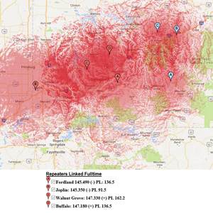
 Southwest Missouri Regional Skywarn’s Interactive Repeater Coverage Map is online. Give it a try. Just click on the “Repeaters” tab along our main navigation menu above. This map is built upon the Google Maps API (Application Programming Interface), and it allows the end user to zoom, pan and select or deselect our various repeaters providing for local coverage predictions with pin-point precision.
Darker red shading on the map means that there is overlapping coverage allowing for the end user to access Southwest Missouri Regional Skywarn via more than one repeater frequency. Repeater locations are noted on the map using two sets of alphabetical markers. Red markers denote repeaters which are linked full time, and blue markers indicate repeaters which only link up during training nets and severe weather outbreaks.
These coverage predictions assume the use of a mobile antenna with unity gain (i.e. a 2 meter ground plane antenna) located upon the roof of a vehicle with the end user delivering 50 watts to the antenna. As a general rule, hand-held radios will receive diminished coverage especially while using “rubber duck” antennas, and base stations and mobile stations with higher gain antennas and/or who transmit more than 50 watts may receive increased coverage than what is represented within this approximation.
Factors such as tropospheric ducting, foliage, local interference from electrical sources, co-channel interference, intermodulation/front-end overload, etc. are not considered within these coverage predictions.
